
Verdun topographic map
Interactive map
Click on the map to display elevation.
About this map
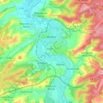
Name: Verdun topographic map, elevation, terrain.
Location: Verdun, Meuse, Grand Est, Metropolitan France, 55100, France (49.11262 5.28097 49.17533 5.44085)
Average elevation: 256 m
Minimum elevation: 187 m
Maximum elevation: 387 m
Other topographic maps
Click on a map to view its topography, its elevation and its terrain.
Bourru
France > Grand Est > Meuse > Saint-Laurent-sur-Othain
Bourru, Saint-Laurent-sur-Othain, Verdun, Meuse, Grand Est, Metropolitan France, 55150, France
Average elevation: 236 m
Ligny-en-Barrois
France > Grand Est > Meuse > Ligny-en-Barrois
Ligny-en-Barrois, Bar-le-Duc, Meuse, Grand Est, Metropolitan France, 55500, France
Average elevation: 308 m