
Le Plat du Loup topographic map
Interactive map
Click on the map to display elevation.
About this map
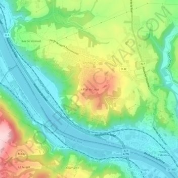
Name: Le Plat du Loup topographic map, elevation, terrain.
Average elevation: 238 m
Minimum elevation: 144 m
Maximum elevation: 417 m
Other topographic maps
Click on a map to view its topography, its elevation and its terrain.
Bas de Seyssuel
France > Auvergne-Rhône-Alpes > Isère > Seyssuel
Bas de Seyssuel, Seyssuel, Vienne, Isère, Auvergne-Rhône-Alpes, France métropolitaine, 38200, France
Average elevation: 236 m