
Swan River topographic map
Interactive map
Click on the map to display elevation.
About this map
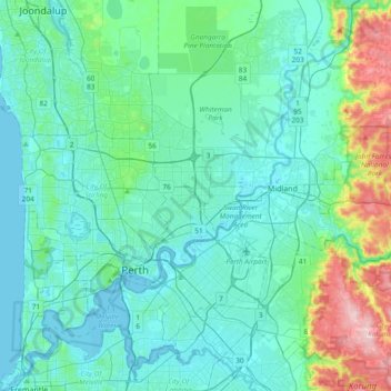
Name: Swan River topographic map, elevation, terrain.
Location: Swan River, City of Perth, Western Australia, Australia (-32.05494 115.73003 -31.73574 116.07277)
Average elevation: 57 m
Minimum elevation: -2 m
Maximum elevation: 353 m
Other topographic maps
Click on a map to view its topography, its elevation and its terrain.
Perth
Australia > Western Australia > City of Perth
Perth, City of Perth, Western Australia, 6000, Australia
Average elevation: 26 m
Crawley
Australia > Western Australia > City of Perth
Crawley, City of Perth, Western Australia, Australia
Average elevation: 13 m