
Thank you for supporting this site ❤️
Make a donation
Make a donation
Samegrelo-Upper Svaneti topographic map
Click on the map to display elevation.
Thank you for supporting this site ❤️
Make a donation
Make a donation
About this map
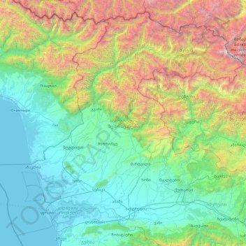
Name: Samegrelo-Upper Svaneti topographic map, elevation, terrain.
Location: Samegrelo-Upper Svaneti, Georgia (42.01441 41.29024 43.25698 43.14623)
Average elevation: 1,104 m
Minimum elevation: -2 m
Maximum elevation: 5,127 m
Thank you for supporting this site ❤️
Make a donation
Make a donation
Other topographic maps
Click on a map to view its topography, its elevation and its terrain.