
Samegrelo-Upper Svaneti topographic map
Interactive map
Click on the map to display elevation.
About this map
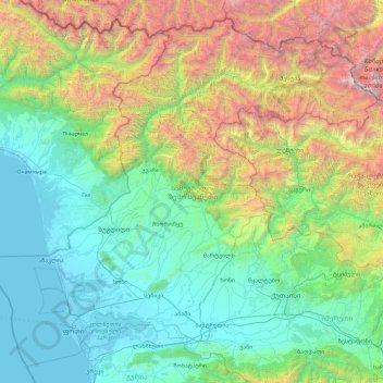
Name: Samegrelo-Upper Svaneti topographic map, elevation, terrain.
Location: Samegrelo-Upper Svaneti, Georgia (42.01441 41.29024 43.25698 43.14623)
Average elevation: 1,104 m
Minimum elevation: -2 m
Maximum elevation: 5,127 m
Other topographic maps
Click on a map to view its topography, its elevation and its terrain.
Shovi
Georgia > Racha-Lechkhumi and Lower Svaneti > Oni Municipality
Shovi, Oni Municipality, Racha-Lechkhumi and Lower Svaneti, Georgia
Average elevation: 1,792 m
Zhabeshi
Georgia > Samegrelo-Upper Svaneti > Zhabeshi
Zhabeshi, Mestia Municipality, Samegrelo-Upper Svaneti, Georgia
Average elevation: 1,990 m
Tsaneri Glacier
Georgia > Samegrelo-Upper Svaneti
Tsaneri Glacier, Mestia Municipality, Samegrelo-Upper Svaneti, Georgia
Average elevation: 3,592 m
Ushba
Georgia > Samegrelo-Upper Svaneti
Ushba, Mestia Municipality, Samegrelo-Upper Svaneti, Georgia
Average elevation: 3,640 m
Stepantsminda
Georgia > Mtskheta-Mtianeti > Stepantsminda
Stepantsminda, Kazbegi Municipality, Mtskheta-Mtianeti, Georgia
Average elevation: 1,855 m
Caucasus Mountains
Caucasus Mountains, Dusheti Municipality, Mtskheta-Mtianeti, Georgia
Average elevation: 2,188 m
Mount Mkinvartsveri (Kazbegi)
Mount Mkinvartsveri (Kazbegi), Kazbegi Municipality, Mtskheta-Mtianeti, Georgia
Average elevation: 4,324 m