
Stewart County topographic map
Interactive map
Click on the map to display elevation.
About this map
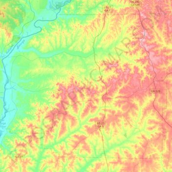
Name: Stewart County topographic map, elevation, terrain.
Location: Stewart County, Géorgie, États-Unis (31.92033 -85.06833 32.23295 -84.63127)
Average elevation: 125 m
Minimum elevation: 53 m
Maximum elevation: 216 m
Other topographic maps
Click on a map to view its topography, its elevation and its terrain.
Crowe Lake
États-Unis > Géorgie > Somerset Hills
Crowe Lake, Old Peachtree Road, Somerset Hills, Gwinnett County, Géorgie, 30091, États-Unis
Average elevation: 349 m
Winder
États-Unis > Géorgie > Winder
Winder, Barrow County, Géorgie, 30680, États-Unis
Average elevation: 274 m
Savannah
États-Unis > Géorgie > Savannah
Savannah, Chatham County, Géorgie, États-Unis
Average elevation: 4 m
Edmunston Creek
Edmunston Creek, Lumpkin County, Géorgie, États-Unis
Average elevation: 490 m