
Pischelsdorf topographic map
Interactive map
Click on the map to display elevation.
About this map
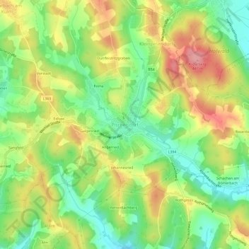
Name: Pischelsdorf topographic map, elevation, terrain.
Average elevation: 390 m
Minimum elevation: 338 m
Maximum elevation: 451 m
Other topographic maps
Click on a map to view its topography, its elevation and its terrain.
Kulmingberg
Österreich > Steiermark > Bezirk Weiz > Pischelsdorf am Kulm
Kulmingberg, Pischelsdorf am Kulm, Bezirk Weiz, Steiermark, 8212, Österreich
Average elevation: 524 m