
Thank you for supporting this site ❤️
Make a donation
Make a donation
Les Régniers topographic map
Click on the map to display elevation.
Thank you for supporting this site ❤️
Make a donation
Make a donation
About this map
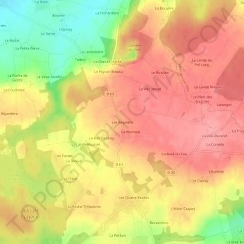
Name: Les Régniers topographic map, elevation, terrain.
Average elevation: 101 m
Minimum elevation: 41 m
Maximum elevation: 135 m
Thank you for supporting this site ❤️
Make a donation
Make a donation
Other topographic maps
Click on a map to view its topography, its elevation and its terrain.
Le vallon de la Chambre au Loup
France > Bretagne > Ille-et-Vilaine > Iffendic > La Perrière
Average elevation: 93 m