
Thank you for supporting this site ❤️
Make a donation
Make a donation
Kirkbampton topographic map
Click on the map to display elevation.
Thank you for supporting this site ❤️
Make a donation
Make a donation
About this map
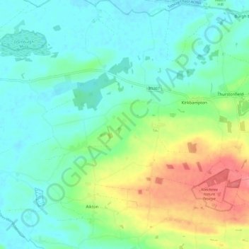
Name: Kirkbampton topographic map, elevation, terrain.
Location: Kirkbampton, Allerdale, Cumbria, England, United Kingdom (54.87455 -3.17010 54.90876 -3.05716)
Average elevation: 26 m
Minimum elevation: 4 m
Maximum elevation: 78 m
Thank you for supporting this site ❤️
Make a donation
Make a donation
Other topographic maps
Click on a map to view its topography, its elevation and its terrain.
Thank you for supporting this site ❤️
Make a donation
Make a donation
Mealsgate
United Kingdom > England > Cumbria > Allerdale > Mealsgate > Fletchertown
Average elevation: 104 m
Thank you for supporting this site ❤️
Make a donation
Make a donation
Milefortlet 9, Skinburness
United Kingdom > England > Cumbria > Allerdale > Skinburness
Average elevation: 3 m
Oughterby
United Kingdom > England > Cumbria > Allerdale > Kirkbampton > Oughterby
Average elevation: 35 m
Thank you for supporting this site ❤️
Make a donation
Make a donation