
Make a donation
Ihlewitz topographic map
Click on the map to display elevation.
Make a donation
About this map
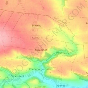
Name: Ihlewitz topographic map, elevation, terrain.
Average elevation: 146 m
Minimum elevation: 80 m
Maximum elevation: 189 m
Make a donation
Other topographic maps
Click on a map to view its topography, its elevation and its terrain.
Make a donation
Make a donation
Rohnetal
Deutschland > Sachsen-Anhalt > Mansfeld-Südharz > Allstedt > Wolferstedt
Average elevation: 172 m
Make a donation
Großer Auerberg
Deutschland > Sachsen-Anhalt > Mansfeld-Südharz
Der Große Auerberg im Harz ist ein 580,4 m ü. NHN hoher Berg bei Stolberg im Gemeindegebiet von Südharz im Landkreis Mansfeld-Südharz in Sachsen-Anhalt. Es handelt sich um einen Doppelgipfel von 580,4 m (Großer Auerberg) und 580,3 m (Josephshöhe) Höhe, die etwa 470 m auseinander liegen.
Average elevation: 479 m
Popperode
Deutschland > Sachsen-Anhalt > Mansfeld-Südharz > Sangerhausen > Popperode
Average elevation: 328 m
Make a donation
Hedersleben (b. Eisleben)
Deutschland > Sachsen-Anhalt > Mansfeld-Südharz > Lutherstadt Eisleben > Hedersleben (b. Eisleben)
Average elevation: 201 m
Wolferode
Deutschland > Sachsen-Anhalt > Mansfeld-Südharz > Lutherstadt Eisleben > Wolferode
Average elevation: 230 m
Sittendorf
Deutschland > Sachsen-Anhalt > Mansfeld-Südharz > Kelbra (Kyffhäuser)
Average elevation: 203 m