
Thank you for supporting this site ❤️
Make a donation
Make a donation
Glenbrook topographic map
Click on the map to display elevation.
Thank you for supporting this site ❤️
Make a donation
Make a donation
About this map
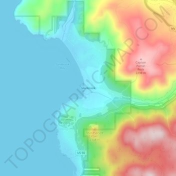
Name: Glenbrook topographic map, elevation, terrain.
Location: Glenbrook, Douglas County, Nevada, 89413, United States (39.06935 -119.95907 39.10935 -119.91907)
Average elevation: 2,015 m
Minimum elevation: 1,896 m
Maximum elevation: 2,284 m
Thank you for supporting this site ❤️
Make a donation
Make a donation
Other topographic maps
Click on a map to view its topography, its elevation and its terrain.