
Thank you for supporting this site ❤️
Make a donation
Make a donation
Takhian Thong topographic map
Click on the map to display elevation.
Thank you for supporting this site ❤️
Make a donation
Make a donation
About this map
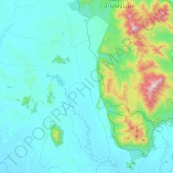
Name: Takhian Thong topographic map, elevation, terrain.
Location: Takhian Thong, Chanthaburi Province, Thailand (12.77082 101.91374 13.09082 102.23374)
Average elevation: 240 m
Minimum elevation: 6 m
Maximum elevation: 1,598 m
Thank you for supporting this site ❤️
Make a donation
Make a donation