
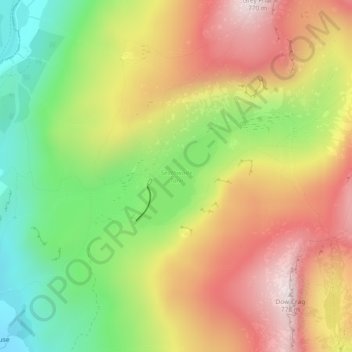
Seathwaite Tarn topographic map
Interactive map
Click on the map to display elevation.
About this map
Name: Seathwaite Tarn topographic map, elevation, terrain.
Average elevation: 456 m
Minimum elevation: 148 m
Maximum elevation: 767 m
Other topographic maps
Click on a map to view its topography, its elevation and its terrain.
Lower Holker
Vereinigtes Königreich > England > South Lakeland
Lower Holker, South Lakeland, Cumbria, Nordwestengland, England, Vereinigtes Königreich
Average elevation: 6 m
Kentmere
Vereinigtes Königreich > England > South Lakeland
Kentmere, South Lakeland, Cumbria, Nordwestengland, England, Vereinigtes Königreich
Average elevation: 403 m