
Schlatzing topographic map
Interactive map
Click on the map to display elevation.
About this map
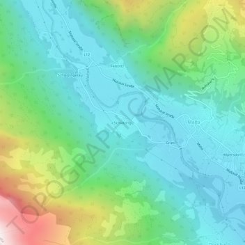
Name: Schlatzing topographic map, elevation, terrain.
Average elevation: 1,149 m
Minimum elevation: 773 m
Maximum elevation: 2,244 m
Other topographic maps
Click on a map to view its topography, its elevation and its terrain.
Hochalmspitze
Österreich > Kärnten > Bezirk Spittal an der Drau > Malta
Hochalmspitze, Malta, Bezirk Spittal an der Drau, Kärnten, 9854, Österreich
Average elevation: 2,857 m