
Thank you for supporting this site ❤️
Make a donation
Make a donation
Orchard Knoll topographic map
Click on the map to display elevation.
Thank you for supporting this site ❤️
Make a donation
Make a donation
About this map
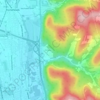
Name: Orchard Knoll topographic map, elevation, terrain.
Average elevation: 336 m
Minimum elevation: 259 m
Maximum elevation: 502 m
Thank you for supporting this site ❤️
Make a donation
Make a donation
Other topographic maps
Click on a map to view its topography, its elevation and its terrain.
Breesport
United States > New York > Chemung County > Town of Horseheads
Breesport is located on the eastern side of the town of Horseheads at 42°10′24″N 076°44′02″W / 42.17333°N 76.73389°W / 42.17333; -76.73389 (42.173408, -76.733841). Its elevation is 1,099 feet (335 m). Its eastern edge is the border between Horseheads and the town of Erin. New York State…
Average elevation: 374 m
Village of Horseheads
United States > New York > Chemung County > Town of Horseheads
Average elevation: 298 m