
Thank you for supporting this site ❤️
Make a donation
Make a donation
Brownsboro topographic map
Click on the map to display elevation.
Thank you for supporting this site ❤️
Make a donation
Make a donation
About this map
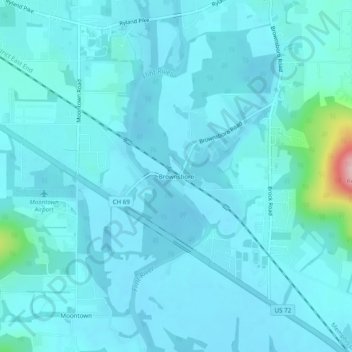
Name: Brownsboro topographic map, elevation, terrain.
Location: Brownsboro, Madison County, Alabama, United States (34.72926 -86.46304 34.76926 -86.42304)
Average elevation: 203 m
Minimum elevation: 183 m
Maximum elevation: 396 m
Thank you for supporting this site ❤️
Make a donation
Make a donation
Other topographic maps
Click on a map to view its topography, its elevation and its terrain.
Thank you for supporting this site ❤️
Make a donation
Make a donation
Harvest
United States > Alabama > Madison County > Harvest
Capshaw Mountain (1,250 feet above sea level) is the only notable geological feature in the area, which extends about 800 feet above the general elevation in the area. The top of this small mountain is the site of several substantial communications towers used by local radio stations. Capshaw Mountain forms a…
Average elevation: 254 m
Thank you for supporting this site ❤️
Make a donation
Make a donation
Thank you for supporting this site ❤️
Make a donation
Make a donation
Thank you for supporting this site ❤️
Make a donation
Make a donation