
Thank you for supporting this site ❤️
Make a donation
Make a donation
Le Rougeret topographic map
Click on the map to display elevation.
Thank you for supporting this site ❤️
Make a donation
Make a donation
About this map
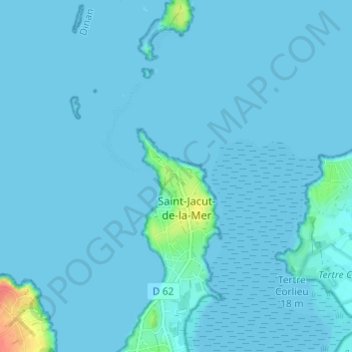
Name: Le Rougeret topographic map, elevation, terrain.
Average elevation: 3 m
Minimum elevation: -2 m
Maximum elevation: 50 m
Thank you for supporting this site ❤️
Make a donation
Make a donation
Other topographic maps
Click on a map to view its topography, its elevation and its terrain.
Plage de Vauvert
France > Bretagne > Côtes-d'Armor > Saint-Jacut-de-la-Mer > La Pépinais
Average elevation: 26 m