
Thank you for supporting this site ❤️
Make a donation
Make a donation
Matoury topographic map
Click on the map to display elevation.
Thank you for supporting this site ❤️
Make a donation
Make a donation
About this map
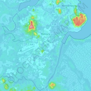
Name: Matoury topographic map, elevation, terrain.
Location: Matoury, Cayenne, French Guiana, 97351, France (4.73819 -52.41193 4.91617 -52.28777)
Average elevation: 11 m
Minimum elevation: -3 m
Maximum elevation: 231 m
Thank you for supporting this site ❤️
Make a donation
Make a donation
Other topographic maps
Click on a map to view its topography, its elevation and its terrain.
Thank you for supporting this site ❤️
Make a donation
Make a donation
Thank you for supporting this site ❤️
Make a donation
Make a donation
Saint-Laurent-du-Maroni
France > French Guiana > Saint-Laurent-du-Maroni > Saint-Laurent-du-Maroni
Average elevation: 9 m