
Thank you for supporting this site ❤️
Make a donation
Make a donation
Ethridge topographic map
Click on the map to display elevation.
Thank you for supporting this site ❤️
Make a donation
Make a donation
About this map
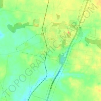
Name: Ethridge topographic map, elevation, terrain.
Average elevation: 296 m
Minimum elevation: 277 m
Maximum elevation: 316 m
Thank you for supporting this site ❤️
Make a donation
Make a donation
Other topographic maps
Click on a map to view its topography, its elevation and its terrain.
Thank you for supporting this site ❤️
Make a donation
Make a donation
Lawrenceburg
United States > Tennessee > Lawrence County > Lawrenceburg
The city of Lawrenceburg has a total area of 12.6 square miles (33 km2). It is the largest city on the state line between Chattanooga and Memphis. Located on the southern Highland Rim, Lawrence County and Lawrenceburg are set atop of a large mountain plateau of the Appalachian Mountain range with elevations…
Average elevation: 278 m