
Thank you for supporting this site ❤️
Make a donation
Make a donation
Mount Desert Island topographic map
Click on the map to display elevation.
Thank you for supporting this site ❤️
Make a donation
Make a donation
About this map
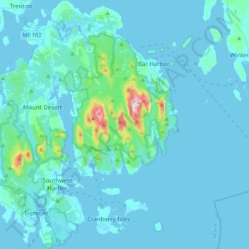
Name: Mount Desert Island topographic map, elevation, terrain.
Location: Mount Desert Island, Hancock County, Maine, United States (44.22164 -68.43149 44.44446 -68.17348)
Average elevation: 29 m
Minimum elevation: -4 m
Maximum elevation: 458 m
Thank you for supporting this site ❤️
Make a donation
Make a donation