
Neufchâteau topographic map
Interactive map
Click on the map to display elevation.
About this map
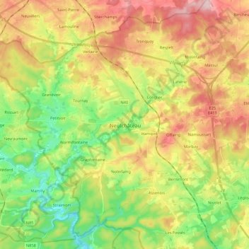
Name: Neufchâteau topographic map, elevation, terrain.
Location: Neufchâteau, Luxembourg, Wallonia, 6840, Belgium (49.77887 5.31496 49.90303 5.52942)
Average elevation: 437 m
Minimum elevation: 338 m
Maximum elevation: 558 m
Other topographic maps
Click on a map to view its topography, its elevation and its terrain.
Semois
Belgium > Luxembourg > Neufchâteau > Herbeumont
Semois, Herbeumont, Neufchâteau, Luxembourg, Wallonia, 6887, Belgium
Average elevation: 312 m
Freux
Belgium > Luxembourg > Neufchâteau
Freux, Libramont-Chevigny, Neufchâteau, Luxembourg, Wallonia, Belgium
Average elevation: 477 m
Tombeau Du Géant
Belgium > Luxembourg > Neufchâteau > Bouillon > Ucimont > Botassart
Tombeau Du Géant, Moulin du Rivage, Botassart, Ucimont, Bouillon, Neufchâteau, Luxembourg, Wallonia, 6833, Belgium
Average elevation: 300 m
Sensenruth
Belgium > Luxembourg > Neufchâteau > Bouillon
Sensenruth, Bouillon, Neufchâteau, Luxembourg, Wallonia, 6832, Belgium
Average elevation: 358 m
Bouillon
Belgium > Luxembourg > Neufchâteau
Bouillon, Neufchâteau, Luxembourg, Wallonia, Belgium
Average elevation: 342 m
Herbeumont
Belgium > Luxembourg > Neufchâteau
Herbeumont, Neufchâteau, Luxembourg, Wallonia, 6887, Belgium
Average elevation: 373 m
Tellin
Belgium > Luxembourg > Neufchâteau
Tellin, Neufchâteau, Luxembourg, Wallonia, 6927, Belgium
Average elevation: 310 m
Bertrix
Belgium > Luxembourg > Neufchâteau
Bertrix, Neufchâteau, Luxembourg, Wallonia, 6880, Belgium
Average elevation: 403 m