
Thank you for supporting this site ❤️
Make a donation
Make a donation
Milam topographic map
Click on the map to display elevation.
Thank you for supporting this site ❤️
Make a donation
Make a donation
About this map
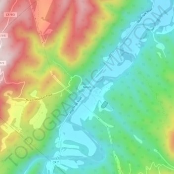
Name: Milam topographic map, elevation, terrain.
Location: Milam, Hardy County, West Virginia, 26838, United States (38.79400 -79.11920 38.83400 -79.07920)
Average elevation: 530 m
Minimum elevation: 343 m
Maximum elevation: 850 m
Thank you for supporting this site ❤️
Make a donation
Make a donation
Other topographic maps
Click on a map to view its topography, its elevation and its terrain.