
Stackpole topographic map
Interactive map
Click on the map to display elevation.
About this map
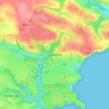
Name: Stackpole topographic map, elevation, terrain.
Average elevation: 38 m
Minimum elevation: -6 m
Maximum elevation: 88 m
Other topographic maps
Click on a map to view its topography, its elevation and its terrain.
Fishguard
Royaume-Uni > Pays de Galles > Pembrokeshire
Fishguard, Pembrokeshire, Pays de Galles, SA65 9AN, Royaume-Uni
Average elevation: 76 m
Roch
Royaume-Uni > Pays de Galles > Pembrokeshire
Roch, Pembrokeshire, Pays de Galles, SA62 6FF, Royaume-Uni
Average elevation: 69 m