
Thank you for supporting this site ❤️
Make a donation
Make a donation
Cape Horn South topographic map
Click on the map to display elevation.
Thank you for supporting this site ❤️
Make a donation
Make a donation
About this map
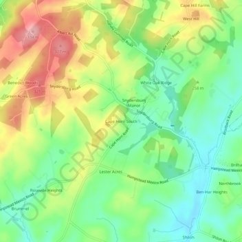
Name: Cape Horn South topographic map, elevation, terrain.
Location: Cape Horn South, Carroll County, Maryland, United States (39.59732 -76.91942 39.63732 -76.87942)
Average elevation: 256 m
Minimum elevation: 201 m
Maximum elevation: 334 m
Thank you for supporting this site ❤️
Make a donation
Make a donation
Other topographic maps
Click on a map to view its topography, its elevation and its terrain.
Avondale Wildlife Management Area
United States > Maryland > Carroll County > Chapel Heights
Average elevation: 206 m
Thank you for supporting this site ❤️
Make a donation
Make a donation