
Thank you for supporting this site ❤️
Make a donation
Make a donation
Höchstädt topographic map
Click on the map to display elevation.
Thank you for supporting this site ❤️
Make a donation
Make a donation
Höchstädt
Das Dorf befindet sich etwa zwei Kilometer nordnordwestlich von Betzenstein auf einer Höhe von 521 m ü. NHN.
Thank you for supporting this site ❤️
Make a donation
Make a donation
About this map
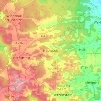
Name: Höchstädt topographic map, elevation, terrain.
Average elevation: 519 m
Minimum elevation: 436 m
Maximum elevation: 586 m
Thank you for supporting this site ❤️
Make a donation
Make a donation