
Haibach topographic map
Interactive map
Click on the map to display elevation.
About this map
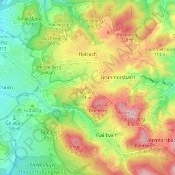
Name: Haibach topographic map, elevation, terrain.
Location: Haibach, Landkreis Aschaffenburg, Bayern, 63808, Deutschland (49.93649 9.18094 49.98025 9.24017)
Average elevation: 245 m
Minimum elevation: 149 m
Maximum elevation: 366 m
Die Gemeinde liegt ost-südöstlich von Aschaffenburg am westlichen Rand des Spessarts zwischen Aschaffenburg und dem Schloss Mespelbrunn. Der topographisch höchste Punkt der Gemeinde befindet sich am Meisberg mit 394 m ü. NHN (Lage)49.938879.24006, der niedrigste liegt am Haibach nordöstlich des Klinikums Aschaffenburg-Alzenau auf 186 m ü. NHN (Lage)49.978389.19369.
Other topographic maps
Click on a map to view its topography, its elevation and its terrain.
Wiesen
Deutschland > Bayern > Landkreis Aschaffenburg
Wiesen, Schöllkrippen, Landkreis Aschaffenburg, Bayern, 63831, Deutschland
Average elevation: 454 m