
Thank you for supporting this site ❤️
Make a donation
Make a donation
Pansipit topographic map
Click on the map to display elevation.
Thank you for supporting this site ❤️
Make a donation
Make a donation
About this map
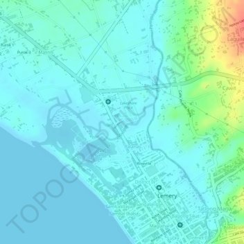
Name: Pansipit topographic map, elevation, terrain.
Location: Pansipit, Lemery, Batangas, Calabarzon, 4209, Philippines (13.89072 120.90492 13.89470 120.91251)
Average elevation: 11 m
Minimum elevation: 0 m
Maximum elevation: 58 m
Thank you for supporting this site ❤️
Make a donation
Make a donation
Other topographic maps
Click on a map to view its topography, its elevation and its terrain.