
Make a donation
New Guinea topographic map
Click on the map to display elevation.
Make a donation
New Guinea
A spine of east–west mountains, the New Guinea Highlands, dominates the geography of New Guinea, stretching over 1,600 km (1,000 mi) across the island, with many mountains over 4,000 m (13,100 ft). The western half of the island contains the highest mountains in Oceania, with its highest point, Puncak Jaya, reaching an elevation of 4,884 m (16,023 ft). The tree line is around 4,000 m (13,100 ft) elevation, and the tallest peaks contain equatorial glaciers—which have been retreating since at least 1936. Various other smaller mountain ranges occur both north and west of the central ranges. Except in high elevations, most areas possess a warm humid climate throughout the year, with some seasonal variation associated with the northeast monsoon season.
Make a donation
About this map
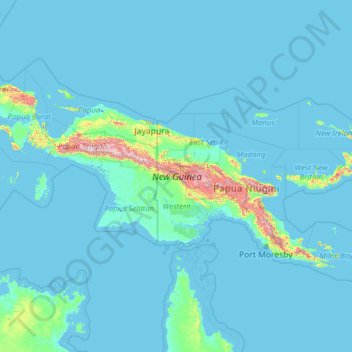
Name: New Guinea topographic map, elevation, terrain.
Location: New Guinea, Southern Region, Papua New Guinea (-10.70169 130.93155 -0.34330 150.87624)
Average elevation: 101 m
Minimum elevation: -4 m
Maximum elevation: 4,441 m
Make a donation
Other topographic maps
Click on a map to view its topography, its elevation and its terrain.
Make a donation
Make a donation
Make a donation
Make a donation
Make a donation
Make a donation
Make a donation
Make a donation
Port Moresby
Papua New Guinea > National Capital District > National Capital District
Average elevation: 34 m
Make a donation
Make a donation
Goroka
Papua New Guinea > Eastern Highlands > Goroka District
Goroka has a subtropical highland climate (Cfb). Due to altitude Goroka features warm to very warm afternoons and cool to mild mornings year-round, with heavy rainfall most of the year and low rainfall from June to September.
Average elevation: 1,890 m
Port Moresby
Papua New Guinea > National Capital District > National Capital District
Average elevation: 34 m
Make a donation
Huon Gulf
Huon Gulf is a large gulf in eastern Papua New Guinea. It is bordered by Huon Peninsula in the north. Both are named after French explorer Jean-Michel Huon de Kermadec. Huon Gulf is a part of the Solomon Sea. Its northern boundary is marked by Cape Cretin, southern by Cape Longerue. The coast, which quickly…
Average elevation: 0 m
Goroka
Papua New Guinea > Eastern Highlands > Goroka District
Goroka has a subtropical highland climate (Cfb). Due to altitude Goroka features warm to very warm afternoons and cool to mild mornings year-round, with heavy rainfall most of the year and low rainfall from June to September.
Average elevation: 1,890 m
Make a donation
Make a donation
Make a donation
Make a donation
Make a donation
Make a donation
Make a donation
Make a donation
Make a donation
Laloki River
Papua New Guinea > National Capital District > National Capital District > Port Moresby
Average elevation: 38 m
Make a donation
Port Moresby
Papua New Guinea > National Capital District > National Capital District
Average elevation: 34 m
Make a donation
Make a donation
Kainantu
Papua New Guinea > Eastern Highlands
A narrow south-east-trending dissected plateau dominates area to the south; it forms the watershed between rivers draining north to the Markham-Ramu Graben, and those draining south to the Papuan coast. The plateau ranges in elevation between 7,500 feet (2,300 m) and 8,000 feet (2,400 m) above sea level, and…
Average elevation: 1,628 m
Make a donation
Make a donation