
Thank you for supporting this site ❤️
Make a donation
Make a donation
Lake Shawnee topographic map
Click on the map to display elevation.
Thank you for supporting this site ❤️
Make a donation
Make a donation
About this map
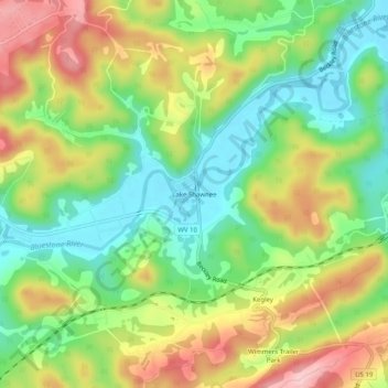
Name: Lake Shawnee topographic map, elevation, terrain.
Average elevation: 712 m
Minimum elevation: 625 m
Maximum elevation: 829 m
Thank you for supporting this site ❤️
Make a donation
Make a donation
Other topographic maps
Click on a map to view its topography, its elevation and its terrain.
Pinnacle Rock State Park
United States > West Virginia > Mercer County > Nemours
Average elevation: 772 m