
Lexington topographic map
Interactive map
Click on the map to display elevation.
About this map
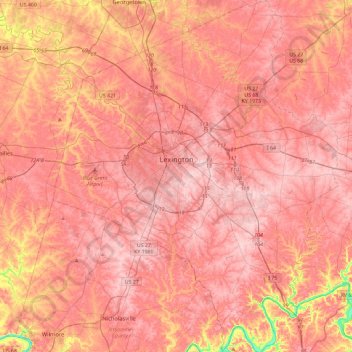
Name: Lexington topographic map, elevation, terrain.
Location: Lexington, Fayette County, Kentucky, United States (37.84530 -84.66042 38.21140 -84.28272)
Average elevation: 281 m
Minimum elevation: 161 m
Maximum elevation: 326 m
Other topographic maps
Click on a map to view its topography, its elevation and its terrain.
Winburn
United States > Kentucky > Fayette County > Lexington
Winburn, Lexington, Fayette County, Kentucky, United States
Average elevation: 292 m
McConnell Springs
United States > Kentucky > Fayette County > Lexington
McConnell Springs, Lexington, Fayette County, Kentucky, United States
Average elevation: 287 m
Shillito Park
United States > Kentucky > Fayette County > Lexington
Shillito Park, Lexington, Fayette County, Kentucky, United States
Average elevation: 307 m
Fenwick
United States > Kentucky > Fayette County > Lexington
Fenwick, Lexington, Fayette County, Kentucky, 40516, United States
Average elevation: 293 m
Paynes
United States > Kentucky > Fayette County > Lexington
Paynes, Lexington, Fayette County, Kentucky, 40504, United States
Average elevation: 289 m
Jonestown
United States > Kentucky > Fayette County > Lexington > Jonestown
Jonestown, Lexington, Fayette County, Kentucky, 40517, United States
Average elevation: 297 m
University of Kentucky Arboretum
United States > Kentucky > Fayette County > Lexington
University of Kentucky Arboretum, Glendover, Lexington, Fayette County, Kentucky, United States
Average elevation: 309 m
Beaumont
United States > Kentucky > Fayette County > Lexington
Beaumont, Lexington, Fayette County, Kentucky, United States
Average elevation: 299 m