
Lampung Selatan topographic map
Interactive map
Click on the map to display elevation.
About this map
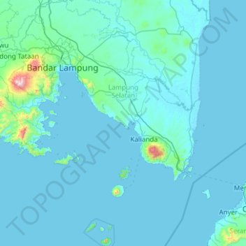
Name: Lampung Selatan topographic map, elevation, terrain.
Location: Lampung Selatan, Lampung, Indonesië (-6.16784 105.11516 -5.17486 105.83874)
Average elevation: 52 m
Minimum elevation: -2 m
Maximum elevation: 1,618 m
Other topographic maps
Click on a map to view its topography, its elevation and its terrain.
Krakatau
Indonesië > Lampung > Lampung Selatan
Krakatau, Lampung Selatan, Lampung, Indonesië
Average elevation: 20 m