
Thank you for supporting this site ❤️
Make a donation
Make a donation
Assmannshausen topographic map
Click on the map to display elevation.
Thank you for supporting this site ❤️
Make a donation
Make a donation
About this map
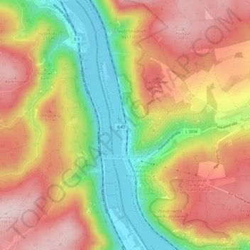
Name: Assmannshausen topographic map, elevation, terrain.
Average elevation: 247 m
Minimum elevation: 73 m
Maximum elevation: 391 m
Thank you for supporting this site ❤️
Make a donation
Make a donation
Other topographic maps
Click on a map to view its topography, its elevation and its terrain.
Teufelskadrich
Deutschland > Hessen > Rheingau-Taunus-Kreis > Rüdesheim am Rhein > Aulhausen
Average elevation: 285 m