
Thank you for supporting this site ❤️
Make a donation
Make a donation
Les Allues topographic map
Click on the map to display elevation.
Thank you for supporting this site ❤️
Make a donation
Make a donation
About this map
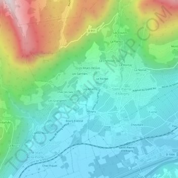
Name: Les Allues topographic map, elevation, terrain.
Average elevation: 565 m
Minimum elevation: 272 m
Maximum elevation: 1,374 m
Thank you for supporting this site ❤️
Make a donation
Make a donation
Other topographic maps
Click on a map to view its topography, its elevation and its terrain.
73250
France > Auvergne-Rhône-Alpes > Savoie > Saint-Pierre-d'Albigny > Le Pechet
Average elevation: 786 m