
Thank you for supporting this site ❤️
Make a donation
Make a donation
Madyan topographic map
Click on the map to display elevation.
Thank you for supporting this site ❤️
Make a donation
Make a donation
About this map
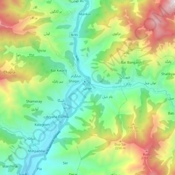
Name: Madyan topographic map, elevation, terrain.
Average elevation: 1,860 m
Minimum elevation: 1,268 m
Maximum elevation: 2,990 m
Thank you for supporting this site ❤️
Make a donation
Make a donation
Other topographic maps
Click on a map to view its topography, its elevation and its terrain.
Mahundand Lake
Pakistan > Khyber Pakhtunkhwa > Swat District > Kalam Tehsil
Average elevation: 3,215 m
Kalam Tehsil
Pakistan > Khyber Pakhtunkhwa > Swat District
At an elevation about 2,000 m (6,600 ft) above sea level, the valley itself provides a plateau that is located above the river and is used for farming. There are a number of visible mountains, also visible from Matiltan, a valley close to Kalam Valley, including Mount Falaksar at 5,918 meters (19,416 feet),…
Average elevation: 3,920 m
Thank you for supporting this site ❤️
Make a donation
Make a donation