
Make a donation
Brighton topographic map
Click on the map to display elevation.
Make a donation
Brighton
Brighton is a suburb of Denver located at coordinates 39°59′07″N 104°49′14″W / 39.9853°N 104.8205°W / 39.9853; -104.8205 (Brighton, Colorado) at an elevation of 4,987 feet (1,520 m).
Make a donation
About this map
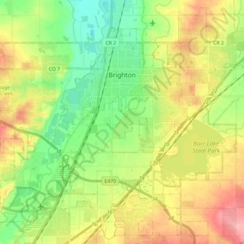
Name: Brighton topographic map, elevation, terrain.
Location: Brighton, Adams County, Colorado, United States (39.89967 -104.88377 40.01854 -104.71716)
Average elevation: 1,545 m
Minimum elevation: 1,497 m
Maximum elevation: 1,608 m
Make a donation
Other topographic maps
Click on a map to view its topography, its elevation and its terrain.
Bennett
United States > Colorado > Adams County
Bennett is located at coordinates 39°45′32″N 104°25′39″W / 39.7589°N 104.4275°W / 39.7589; -104.4275 at an elevation of 5486 at the intersection of State Highways 36 and 79, just north of Interstate 70.
Average elevation: 1,692 m
Bennett
United States > Colorado > Adams County
Bennett is located at coordinates 39°45′32″N 104°25′39″W / 39.7589°N 104.4275°W / 39.7589; -104.4275 at an elevation of 5486 at the intersection of State Highways 36 and 79, just north of Interstate 70.
Average elevation: 1,692 m
Make a donation
Broomfield McKay Bike Park
United States > Colorado > Adams County > Broomfield
Average elevation: 1,601 m
Westminster
United States > Colorado > Adams County > Westminster > Westminster
Average elevation: 1,660 m
Make a donation