
El Bayadh topographic map
Interactive map
Click on the map to display elevation.
About this map
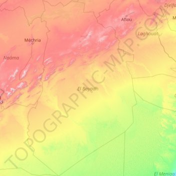
Name: El Bayadh topographic map, elevation, terrain.
Location: El Bayadh, RADP (30.70166 -0.41587 34.44817 2.36031)
Average elevation: 852 m
Minimum elevation: 370 m
Maximum elevation: 2,173 m
Other topographic maps
Click on a map to view its topography, its elevation and its terrain.
El Abiodh Sidi Cheikh
RADP > El Bayadh > El Abiodh Sidi Cheikh
El Abiodh Sidi Cheikh, daïra El Abiodh Sidi Cheikh, El Bayadh, 32003, RADP
Average elevation: 776 m