
清湾镇 topographic map
Interactive map
Click on the map to display elevation.
About this map
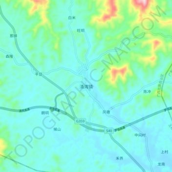
Name: 清湾镇 topographic map, elevation, terrain.
Location: 清湾镇, 北流市, 玉林市, 广西壮族自治区, 543000, 中国 (22.18801 110.56490 22.26801 110.64490)
Average elevation: 116 m
Minimum elevation: 51 m
Maximum elevation: 444 m
Other topographic maps
Click on a map to view its topography, its elevation and its terrain.