
Make a donation
Mercer County topographic map
Click on the map to display elevation.
Make a donation
Mercer County
The county is generally flat and low-lying on the inner coastal plain, which extends up to the Route 1 corridor. Further northwest, terrain rises as it ascends the Piedmont Plateau, with The Sourlands encompassing the far northwestern portion of the county. Baldpate Mountain, in the western part of Hopewell Township, is the highest point in the county, at 480 feet (150 m) above sea level. The lowest elevation is sea level, spread out along the shores of the tidal portions of the Delaware River, Crosswicks Creek and the smaller waterways within the Trenton-Hamilton Marsh in Hamilton Township and the city of Trenton.
Make a donation
About this map
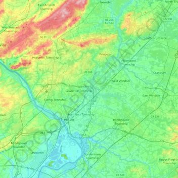
Name: Mercer County topographic map, elevation, terrain.
Location: Mercer County, New Jersey, United States (40.13684 -74.94291 40.42423 -74.48120)
Average elevation: 43 m
Minimum elevation: 0 m
Maximum elevation: 176 m
Make a donation
Other topographic maps
Click on a map to view its topography, its elevation and its terrain.
Watchung Reservation
United States > New Jersey > Union County > Mountainside
Average elevation: 118 m
Make a donation
Green Brook
United States > New Jersey > Somerset County > Green Brook Township
Average elevation: 43 m
Make a donation
Make a donation
Make a donation
Sommers Boy Scout Park
United States > New Jersey > Monmouth County > Oceanport > Sands Point
Average elevation: 2 m
Make a donation
Navesink
United States > New Jersey > Monmouth County > Middletown Township > Navesink
Average elevation: 27 m
Make a donation
Mount Tammany
United States > New Jersey > Warren County > Knowlton Township
Hiking on Mount Tammany consists of two trails: the red dot trail and the blue dot trail. The red dot trail is 1.2 miles and the blue dot trail is 1.8 miles. Combining the two for one of NJ's most popular hikes is a 3 mile loop. There is a 1201 feet elevation change going up and down the mountain. Generally,…
Average elevation: 267 m
Springtown
United States > New Jersey > Morris County > Washington Township > Long Valley
Average elevation: 270 m
Indian Mills
United States > New Jersey > Burlington County > Shamong Township
Average elevation: 25 m
Make a donation
Boonton Township
United States > New Jersey > Morris County > Boonton Township
Average elevation: 192 m
First Watchung Mountain
United States > New Jersey > Somerset County > Bridgewater Township
Average elevation: 55 m
Mystic Islands
United States > New Jersey > Ocean County > Little Egg Harbor Township
Average elevation: 1 m
Make a donation
Mickleton
United States > New Jersey > Gloucester County > East Greenwich Township
Average elevation: 18 m
Petersburg
United States > New Jersey > Warren County > Independence Township
Average elevation: 241 m
Make a donation
North Middletown
United States > New Jersey > Monmouth County > Middletown Township
Average elevation: 4 m
Make a donation
New Market
United States > New Jersey > Middlesex County > Piscataway Township
Average elevation: 23 m
Make a donation
Lake Neepaulin
United States > New Jersey > Sussex County > Wantage
Lake Neepaulin is a man-made lake created from the damming of Neepaulakating Creek, a small mountain stream that was not named until 2002. The creek's headwaters are located approximately 0.4 miles (0.64 km) northwest of the north end of Lake Neepaulin. These headwaters are located a short distance south of…
Average elevation: 172 m
Make a donation
Danville Mountain
United States > New Jersey > Warren County > Liberty Township
Average elevation: 232 m
Make a donation
Make a donation
Franklin Park
United States > New Jersey > Burlington County > Willingboro Township
Average elevation: 11 m
Make a donation
Make a donation
Twin Rivers
United States > New Jersey > Mercer County > East Windsor Township
Average elevation: 35 m
Make a donation
Make a donation
Six Mile Run
United States > New Jersey > Middlesex County > North Brunswick > Adams
Average elevation: 34 m
Shongum Lake Dam
United States > New Jersey > Morris County > Randolph Township
Average elevation: 255 m
Make a donation
Mount Pleasant
United States > New Jersey > Monmouth County > Marlboro Township
Average elevation: 58 m
Make a donation
Orchard Heights
United States > New Jersey > Middlesex County > East Brunswick Township
Average elevation: 32 m
Chapel Hill
United States > New Jersey > Monmouth County > Middletown Township
Average elevation: 27 m
Stone Tavern
United States > New Jersey > Monmouth County > Upper Freehold Township
Average elevation: 62 m
Make a donation
Franklinville
United States > New Jersey > Gloucester County > Franklin Township
Average elevation: 32 m
Blackwells Mills
United States > New Jersey > Somerset County > Franklin Township
Average elevation: 24 m
Bradley Gardens
United States > New Jersey > Somerset County > Bridgewater Township
Average elevation: 28 m
Make a donation
Franklin Park Natural Area
United States > New Jersey > Somerset County > Franklin Township
Average elevation: 40 m
Make a donation
Shore View
United States > New Jersey > Middlesex County > Woodbridge Township > Colonia
Average elevation: 29 m
Wertsville
United States > New Jersey > Hunterdon County > East Amwell Township
Average elevation: 72 m
Make a donation
Rockefellows Mills
United States > New Jersey > Hunterdon County > Raritan Township
Average elevation: 46 m
Make a donation