
Thank you for supporting this site ❤️
Make a donation
Make a donation
Mehedorf topographic map
Click on the map to display elevation.
Thank you for supporting this site ❤️
Make a donation
Make a donation
About this map
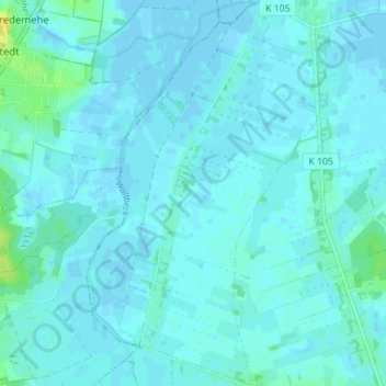
Name: Mehedorf topographic map, elevation, terrain.
Average elevation: 3 m
Minimum elevation: -2 m
Maximum elevation: 21 m
Thank you for supporting this site ❤️
Make a donation
Make a donation
Other topographic maps
Click on a map to view its topography, its elevation and its terrain.
Hesedorf
Deutschland > Niedersachsen > Landkreis Rotenburg (Wümme) > Bremervörde
Average elevation: 18 m
Nieder Ochtenhausen
Deutschland > Niedersachsen > Landkreis Rotenburg (Wümme) > Bremervörde
Average elevation: 5 m
Ottendorf
Deutschland > Niedersachsen > Landkreis Rotenburg (Wümme) > Bremervörde
Average elevation: 2 m
Hönau-Lindorf
Deutschland > Niedersachsen > Landkreis Rotenburg (Wümme) > Bremervörde > Hönau-Lindorf
Average elevation: 4 m
Thank you for supporting this site ❤️
Make a donation
Make a donation
Iselersheim
Deutschland > Niedersachsen > Landkreis Rotenburg (Wümme) > Bremervörde
Average elevation: 2 m