
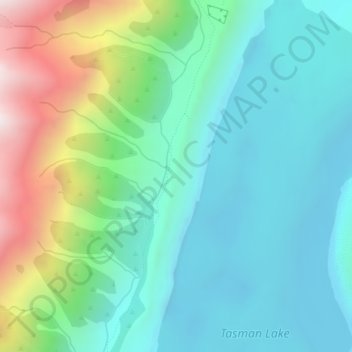
Tasman Glacier and Lake Viewpoint topographic map
Interactive map
Click on the map to display elevation.
About this map
Name: Tasman Glacier and Lake Viewpoint topographic map, elevation, terrain.
Average elevation: 979 m
Minimum elevation: 707 m
Maximum elevation: 1,752 m
Other topographic maps
Click on a map to view its topography, its elevation and its terrain.
Lake Tekapo
Nouvelle-Zélande > Canterbury > Mackenzie District > Lake Tekapo
Lake Tekapo, Mackenzie District, Canterbury, Nouvelle-Zélande
Average elevation: 744 m
Glentanner
Nouvelle-Zélande > Canterbury > Mackenzie District > Glentanner
Glentanner, Mackenzie District, Canterbury, Nouvelle-Zélande
Average elevation: 647 m
Aoraki/Mont Cook
Nouvelle-Zélande > Canterbury > Mackenzie District
Aoraki/Mont Cook, Mackenzie District, Canterbury, Nouvelle-Zélande
Average elevation: 2,920 m
Aiguilles Rouges
Nouvelle-Zélande > Canterbury > Mackenzie District
Aiguilles Rouges, Mackenzie District, Canterbury, Nouvelle-Zélande
Average elevation: 2,342 m