
Nam Nao National Park topographic map
Interactive map
Click on the map to display elevation.
About this map
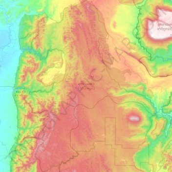
Name: Nam Nao National Park topographic map, elevation, terrain.
Location: Nam Nao National Park, Chaiyaphum Province, Thailand (16.50186 101.36764 16.95944 101.73759)
Average elevation: 676 m
Minimum elevation: 153 m
Maximum elevation: 1,305 m
Other topographic maps
Click on a map to view its topography, its elevation and its terrain.
Chaiyaphum Province
Thailand > Chaiyaphum Province
Chaiyaphum Province, Thailand
Average elevation: 317 m
Thep Sathit
Thailand > Chaiyaphum Province > Thep Sathit
Thep Sathit, Chaiyaphum Province, Thailand
Average elevation: 294 m