
Thank you for supporting this site ❤️
Make a donation
Make a donation
Lichte topographic map
Click on the map to display elevation.
Thank you for supporting this site ❤️
Make a donation
Make a donation
About this map
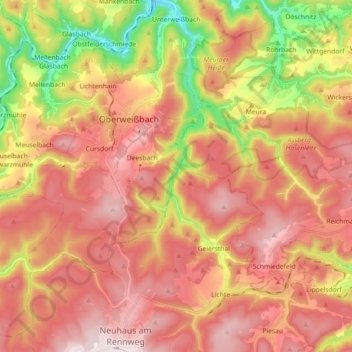
Name: Lichte topographic map, elevation, terrain.
Average elevation: 622 m
Minimum elevation: 320 m
Maximum elevation: 834 m
Thank you for supporting this site ❤️
Make a donation
Make a donation
Other topographic maps
Click on a map to view its topography, its elevation and its terrain.
Steinheid
Deutschland > Thüringen > Landkreis Sonneberg > Neuhaus am Rennweg
Der staatlich anerkannte Erholungsort Steinheid liegt auf dem Kamm des Thüringer Schiefergebirges, unmittelbar am Rennsteig. Der Ort liegt halbmondförmig über dem Tal der Grümpen. Mit 820 Metern Höhe ist Steinheid neben Neuhaus am Rennweg (835 m) einer der höchstgelegenen Orte Thüringens. Der höchste…
Average elevation: 755 m
Hügel
Deutschland > Thüringen > Landkreis Sonneberg > Neuhaus am Rennweg > Lichte
Average elevation: 699 m