
Thank you for supporting this site ❤️
Make a donation
Make a donation
Toulouse topographic map
Click on the map to display elevation.
Thank you for supporting this site ❤️
Make a donation
Make a donation
Toulouse
The first half of the 14th century was a prosperous period, despite the dismemberment in 1317 of the very large bishopric of Toulouse (which lost two thirds of its area and a large part of its income, a loss only partially compensated by its elevation to the rank of archbishopric), and the episode of the Shepherds' Crusade which brought a pogrom against Toulouse's Jewish population in 1320.
Thank you for supporting this site ❤️
Make a donation
Make a donation
About this map
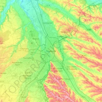
Name: Toulouse topographic map, elevation, terrain.
Average elevation: 173 m
Minimum elevation: 104 m
Maximum elevation: 288 m
Thank you for supporting this site ❤️
Make a donation
Make a donation