
Thank you for supporting this site ❤️
Make a donation
Make a donation
Langenfeld topographic map
Click on the map to display elevation.
Thank you for supporting this site ❤️
Make a donation
Make a donation
About this map
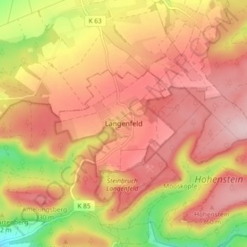
Name: Langenfeld topographic map, elevation, terrain.
Average elevation: 273 m
Minimum elevation: 127 m
Maximum elevation: 359 m
Thank you for supporting this site ❤️
Make a donation
Make a donation
Other topographic maps
Click on a map to view its topography, its elevation and its terrain.
Hohenstein
Deutschland > Niedersachsen > Landkreis Hameln-Pyrmont > Hessisch Oldendorf > Rohdental
Average elevation: 243 m