
Thank you for supporting this site ❤️
Make a donation
Make a donation
West Auckland topographic map
Click on the map to display elevation.
Thank you for supporting this site ❤️
Make a donation
Make a donation
About this map
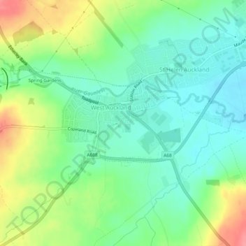
Name: West Auckland topographic map, elevation, terrain.
Average elevation: 124 m
Minimum elevation: 96 m
Maximum elevation: 177 m
Thank you for supporting this site ❤️
Make a donation
Make a donation
Other topographic maps
Click on a map to view its topography, its elevation and its terrain.
College of St Hild and St Bede
United Kingdom > England > County Durham > Durham
Average elevation: 64 m