
Moulin topographic map
Interactive map
Click on the map to display elevation.
About this map
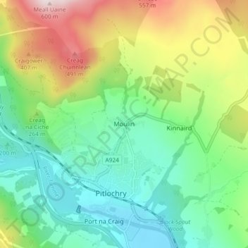
Name: Moulin topographic map, elevation, terrain.
Location: Moulin, Perth and Kinross, Écosse, PH16 5EW, Royaume-Uni (56.69313 -3.74683 56.73313 -3.70683)
Average elevation: 243 m
Minimum elevation: 76 m
Maximum elevation: 580 m
Other topographic maps
Click on a map to view its topography, its elevation and its terrain.
Blairgowrie and Rattray
Royaume-Uni > Écosse > Perth and Kinross
Blairgowrie and Rattray, Perth and Kinross, Écosse, PH10 6AB, Royaume-Uni
Average elevation: 121 m
Dunning
Royaume-Uni > Écosse > Perth and Kinross
Dunning, Perth and Kinross, Écosse, PH2 0RT, Royaume-Uni
Average elevation: 91 m
Crieff
Royaume-Uni > Écosse > Perth and Kinross
Crieff, Perth and Kinross, Écosse, PH7 3BS, Royaume-Uni
Average elevation: 115 m
Luncarty
Royaume-Uni > Écosse > Perth and Kinross
Luncarty, Perth and Kinross, Écosse, PH1 3YU, Royaume-Uni
Average elevation: 37 m
Scotlandwell
Royaume-Uni > Écosse > Perth and Kinross
Scotlandwell, Perth and Kinross, Écosse, KY13 9NA, Royaume-Uni
Average elevation: 168 m