
Make a donation
Hohenaschau topographic map
Click on the map to display elevation.
Make a donation
Hohenaschau
Aschach | Aschau im Chiemgau | Attich | Aufham | Außerkoy | Außerwald | Bach | Berg | Brückl | Bucha | Einfang | Engerndorf | Fellerer | Göttersberg | Grattenbach | Grenzhub | Grünwald | Hainbach | Haindorf | Hammerbach | Hintergschwendt | Hohenaschau im Chiemgau | Höhenberg | Hub | Huben | Innerkoy | Innerwald | Kohlstatt | Mitterleiten | Pölching | Reichenau | Sachrang | Schlechtenberg | Schoßrinn | Schwarzenstein | Schweibern | Seehaus | Spöck | Staffelstein | Stein | Vordergschwendt | Wald | Wasserthal | Weiher
Make a donation
About this map
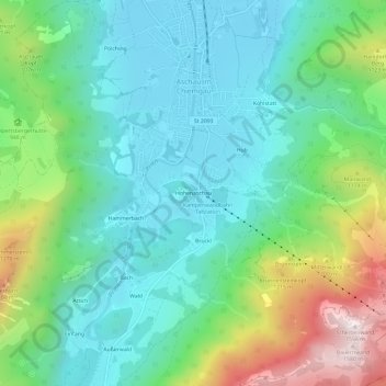
Name: Hohenaschau topographic map, elevation, terrain.
Average elevation: 863 m
Minimum elevation: 597 m
Maximum elevation: 1,566 m
Make a donation
Other topographic maps
Click on a map to view its topography, its elevation and its terrain.
83229
Deutschland > Bayern > Landkreis Rosenheim > Aschau im Chiemgau > Schoßrinn
Average elevation: 904 m