
Lune topographic map
Interactive map
Click on the map to display elevation.
About this map
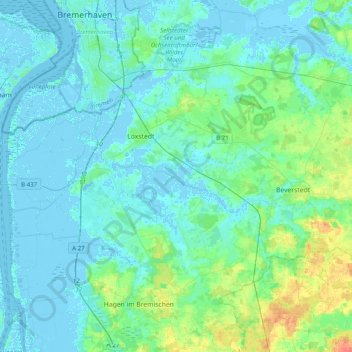
Name: Lune topographic map, elevation, terrain.
Location: Lune, Cuxhaven (arrondissement), Basse-Saxe, Allemagne (53.41861 8.49343 53.46697 8.88743)
Average elevation: 6 m
Minimum elevation: -6 m
Maximum elevation: 37 m
Other topographic maps
Click on a map to view its topography, its elevation and its terrain.
Wanna
Allemagne > Basse-Saxe > Cuxhaven (arrondissement)
Wanna, Samtgemeinde Land Hadeln, Cuxhaven (arrondissement), Basse-Saxe, 21776, Allemagne
Average elevation: 2 m
Oxstedt
Allemagne > Basse-Saxe > Cuxhaven (arrondissement) > Cuxhaven > Oxstedt
Oxstedt, Cuxhaven, Cuxhaven (arrondissement), Basse-Saxe, Allemagne
Average elevation: 11 m