
Thank you for supporting this site ❤️
Make a donation
Make a donation
Keur Massar topographic map
Click on the map to display elevation.
Thank you for supporting this site ❤️
Make a donation
Make a donation
About this map
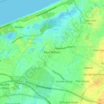
Name: Keur Massar topographic map, elevation, terrain.
Average elevation: 9 m
Minimum elevation: -4 m
Maximum elevation: 23 m
Thank you for supporting this site ❤️
Make a donation
Make a donation
Other topographic maps
Click on a map to view its topography, its elevation and its terrain.
Étang de Mbeubeuss
Sénégal > Région de Dakar > Commune de Keur Massar Nord > Keur Massar
Average elevation: 5 m