
Dhofar Governorate topographic map
Interactive map
Click on the map to display elevation.
About this map
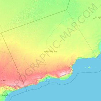
Name: Dhofar Governorate topographic map, elevation, terrain.
Location: Dhofar Governorate, Oman (16.46496 52.00000 20.00000 56.60995)
Average elevation: 238 m
Minimum elevation: 0 m
Maximum elevation: 1,715 m
Other topographic maps
Click on a map to view its topography, its elevation and its terrain.
Sohar
Oman > Al Batinah North Governorate > Sohar
Sohar, Al Batinah North Governorate, 360311, Oman
Average elevation: 27 m
Nizwa
Oman > Ad Dakhiliyah Governorate > Nizwa
Nizwa, Ad Dakhiliyah Governorate, 611, Oman
Average elevation: 774 m
Al Hajar Mountains
Oman > Al Batinah South > Ar Rustaq
Al Hajar Mountains, Ar Rustaq, Al Batinah South, Oman
Average elevation: 2,502 m